

Aberdeenshire’s majestic landscape offers the perfect backdrop for tranquil walks, wildlife discovery and learning more about history – it might even bring out your adventurous side! There are many hiking and walking routes that you can explore in the region, regardless of your fitness level. Go on an easy, moderate or advanced hike by following our guide.
Easy route: Scolty Hill
RGU student Joanne MacWilliam just completed her final year of BA (Hons) Social Work and shares with us an easily accessible hike that she has been doing since she was a child.

Introducing the route
Scolty Hill is a very popular climb in Banchory which allows hikers to reach the summit within an hour or so. Walkers can start at the car park and finish the hike with a stunning view of Banchory and further afield, if you choose a clear day. There is also the opportunity to climb up Scolty Tower when you reach the top.

There are two main routes up to Scolty Tower. Both routes are accessible by leaving the car park and going past the first gate. Then continuing on, ensure to stay to the left of the track until you reach the second gate.
If you wish to take a gentler inclining route to the top, then once through the second gate, veer right and continue the route round the hill until you reach Scolty Tower. This can take under an hour with views of Clachnaben at the back of Scolty Hill.
If you wish for a more advanced, uphill hike that can get you to Scolty Tower in the quickest time, turn left from the second gate and take the next right. There, you will climb the steep slope up the stony path. Once at the top, you can appreciate views reaching Lochnagar and the North Sea.
There are a variety of routes which you can take around Scotly Hill if you are more intrigued by lower-level walking. These routes will take you through woodlands to clearings, which offer brilliant views of the River Dee. I have experienced these routes whilst riding a mountain bike rather than walking, and it was really fun!
Planning your hike
I would suggest bringing water and a picnic as you never know how long you will be out for or where you may end up with the path you choose to take. Preparation will not take long for this accessible hike up or around Scolty Hill. However, it may be beneficial to plan which route you will take in advance to avoid any unexpected terrain.
On a still summer day, be aware that there could be midges! This will require you to bring repellent.
Exploring the history and wildlife
Scolty Tower, reaching 20 metres tall, was built in 1840 as a memorial for General William Burnett. He is known for fighting alongside Wellington in the Napoleonic Wars. Since then, the tower and spiral staircase has been restored and a viewing platform was installed at the top of the tower. Today, it attracts visitors who want to admire the views. Up there, you can see Hill of Fare and Bennachie to the North, Aberdeen to the East, Clachnaben in the South and Mount Keen and Morven to the West.

The woodlands of Scotly Hill are predominantly fir and pine trees, although there are areas of heath on the side of the hill with native species such as, birch, rowan, oak and alder trees. You can often hear woodpeckers in Spring drumming the trees with their beaks, which is a territorial call. In addition, jays, red squirrels and roe deers can be in abundance if you are lucky enough to see them.

Favourite memory of the hike
I have been hiking Scolty Hill since I was a young child as I was brought up in Deeside. I have a lot of great memories of walking up to Scolty Tower. But, when we were in lockdown, I appreciated even more what the spectacular landscape could offer and what was right on my doorstep.
It is a walk that I will never get tired of. It is accessible to almost everyone as you don’t have to be into hiking or have any equipment to walk up or around Scolty Hill. That is why it is such a popular walk!
Moderate route: Cruden Bay – Bullers of Buchan
Clara, Digital Content Assistant at RGU, shares a longer but still widely accessible route that will take you through Slains Castles and along Aberdeenshire’s dramatic coastline.

Introducing the route
The route starts in Cruden Bay, one of my favourite places in Aberdeenshire. This small village is popular among tourists for its sandy beach and crystal water, which you can walk along before starting your hike.

The 9.0-km loop trail will take you two and a half hours to complete and is considered moderately challenging. Indeed, while the walk is relatively short, the terrain can often be muddy and slippery, especially during autumn and winter. You should also be careful of the unprotected cliff edges and uneven terrain in some parts. If you are wanting to go for a much longer walk, you could follow the trail until Boddam, which will take you between 4 and 5 hours to complete.
I discovered this trail when I was planning a day-trip to Slains Castle with my parents who were visiting from France. As someone who doesn’t hike very often, I was charmed by this trail as you can stop halfway through the walk to explore the ruins of the castle. The views are also breath-taking, with natural arches and the North Sea meeting majestic cliffs.
Planning your hike
You should plan how you will travel from Aberdeen to Cruden Bay and back. It only takes 35 minutes to reach the village with a car, but public transportation is also available. Stagecoach operates buses from Aberdeen to Ellon and from Ellon to Cruden Bay which will take just over an hour and a half. Definitely worth it in my opinion!
I would advise to check the weather in advance to pick a day that won’t be wet, as rain will make the terrain more muddy and increase chances of falling. Make sure to check the wind as well! When I did the trail, I packed a picnic and sat on a small hill near the ruins of Slains Castle. I think you should do the same as it will give you the opportunity to admire the sea view while taking a well-deserved break!
Exploring the history and wildlife
Slains Castle was built in 1597 by the Earl of Erroll, and has been reconstructed many times since until it became abandoned in 1925. It is also famous for being the inspiration behind Bram Stoker’s Count Dracula written in 1897.

Bullers of Buchan is a collapsed sea cave where you will find different species of seabirds. During spring and summer, you can spot puffins, kittiwakes, guillemots and razorbills. It’s also during this time that you will be able to admire the cliffside at its most colourful with campions, heathers and orchids becoming part of the scenery.

Favourite memory of the hike
I think sitting down for lunch surrounded by the castle ruins and admiring the landscape was definitely a highlight for me. It made me appreciate the simple but majestic beauty of Aberdeenshire. Another highlight was trying to identify birds and plants that we came across along the way, which peaked an interest in me to learn more about the wildlife on my doorstep.
Advanced route: Cairn Toul -Braeriach traverse
RGU’s Digital Content Manager Sean shares one of his favourite advanced hikes, only to be tackled by people with previous hiking experience!

Introducing the route
This is definitely one of the more difficult hikes. Compared with some other Scottish hill walks, it’s probably not one of the more dangerous ones though. It doesn’t have narrow ridges or anything like that but it’s a long day out. They recommend around 13 hours of walking because it’s about 25 miles. I did it in one day but there are options to camp. There’s a bothy on the route which is a small shelter you find in remote areas. People might take a sleeping bag and sleep in there.
The hike takes in three of the UK’s five highest mountains. It also includes one of my favourite mountains which is Braeriach. I like it because it has amazing views of Deeside and Aberdeenshire. It also has quite spectacular cliffs and quarries around it as well. It’s one of my favourite routes as you’re really far removed from things, it’s very peaceful.
The other very interesting thing about Braeriach is that it’s the source of the River Dee, which goes past the RGU campus. The route is also in the Cairngorms, which sometimes don’t get as much credit among hillwalkers as some of the other mountain regions. But I think this route is definitely up there with anything else that I’ve done in Scotland in terms of the views that you get and the challenge that it gives!
Planning your hike
You can start your hike at a place called Linn of Dee, but a better walk is to do it from closer to Aviemore, and it’s about a two-hour drive from Aberdeen. In terms of fitness level, it’s probably for someone who’s done a bit of hillwalking before. You might want to do some smaller routes in advance to build up fitness to do it. A couple of good ones in the local area to do that on are Mount Keen, Dreish and Mayar that can be done together, or Lochnagar.
The main thing for me when you’re on a long day out like that would be to bring plenty of water and food. You need to make sure you don’t dehydrate. There are plenty of places on this particular route where you can refill your water though, more so than others. You should also bring a map and/or a GPS watch to help you find your way.
Any other equipment you will need to bring will depend on the weather conditions. Before starting your hike, check what the weather is going to be like, but be careful of weather forecasts you see on TV as they are different to what you will get in the mountains. You should look at a mountain-specific forecast. There’s one called Mountain Weather Information Service (MWIS) which updates regularly with forecasts for different areas around the country and there are others that give forecasts for individual mountains.
If it’s wet and raining, you might get soaked, which isn’t great, but I always think that it’s worse if you have really strong winds, as it makes the mountain range very dangerous. Winds can be more of a showstopper in my opinion, but still make sure to bring a waterproof kit if the weather predicts rain.
Always plan out your hike using something like the WalkHighlands website, which has lots of routes with maps and directions.
Exploring the history and wildlife
On this route, there’s a mountain pass – Lairig Ghru – which links up Braemar in Deeside to Aviemore. These places are actually quite close together as the crow flies but they’re not very accessible for people to get between. They’re only about 25/30 miles apart but to drive from one to the other would take you about 2 hours, because you have to go around the mountains. The local area around Braemar also has quite a lot of history, because of Balmoral Castle and its royal connection.

There are many ptarmigans up there. It’s quite a well-known bird that you can find in the hills. You quite often see them around rocky areas, which protect them from predators as they have evolved to camouflage with their feathers changing from a greyish colour in the summer to white in the winter.
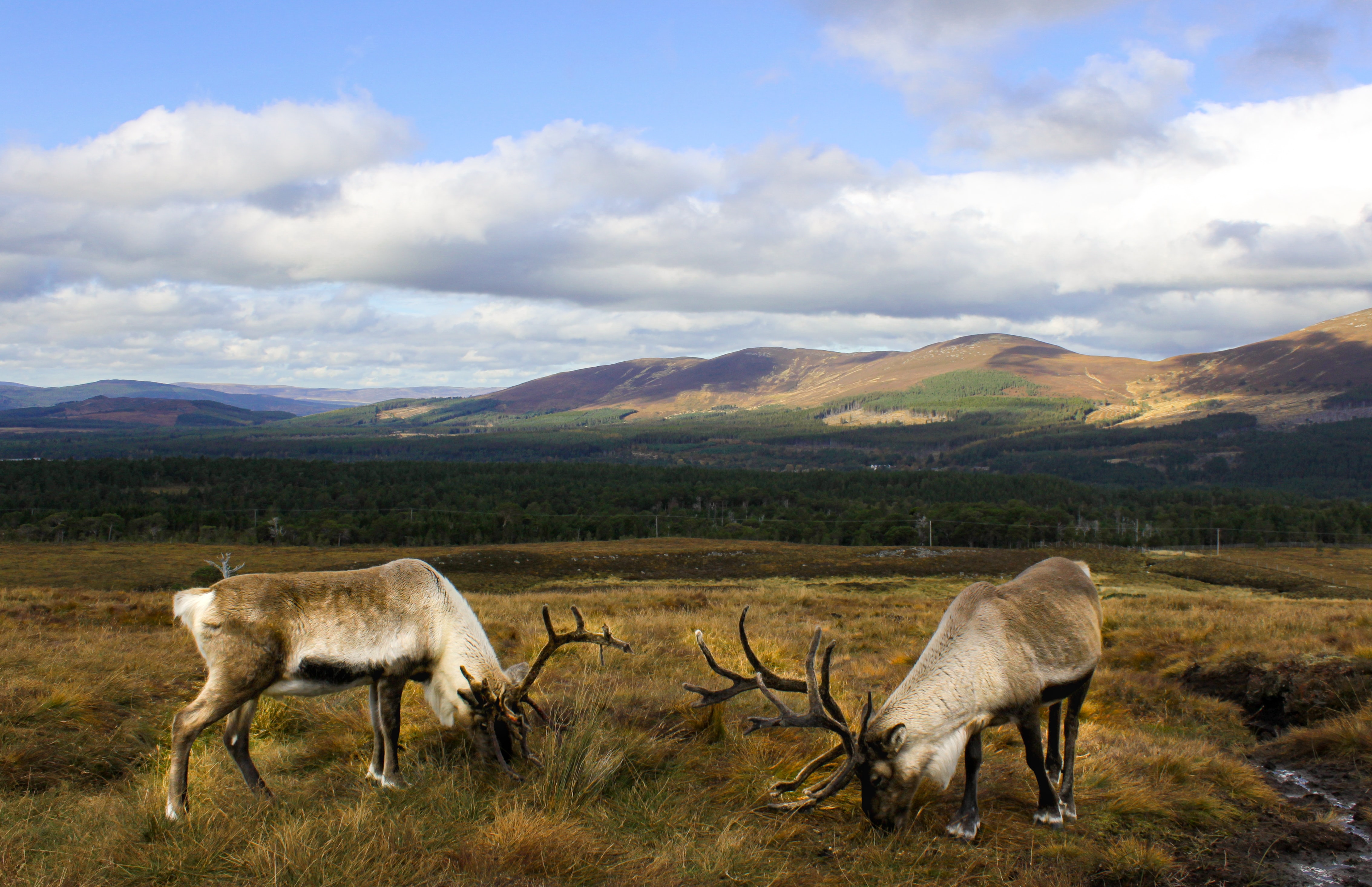
In that same mountain range there is also the UK’s only herd of free-ranging reindeers. They were brought over to Scotland from Sweden years ago because the landscape was similar. You can see them at Christmas and feed them. They make a really weird noise because they’re constantly eating.
Favourite memory of the hike
Because it was a tough day out, my highlight of the hike was probably finishing it! More seriously, the weather was the highlight of the experience for me. It was a nice day out, with nice weather, so I was lucky.
Wheelchair-friendly route: Bennachie Discovery Trail
If you are a wheelchair-user, you should visit Bennachie Visitor Centre. There, you will find more information about an easy and wheelchair-friendly route called the Discovery Trail! This trail is smooth, has no obstacles and only a few gentle slopes, with a rest area at the end of the route. It will take you only around 30 minutes to complete the trail but you can take your time and try to spot some of the local wildlife!
You can find more wheelchair-friendly hikes online.